![](/images/other/stat-length.png)
![Excursión Senderismo Kleines Wiesental - 10200791- kalbelescheur - Photo](https://media.geolcdn.com/t/1900/400/ext.pjpeg?maxdim=2&url=https%3A%2F%2Fstatic1.geolcdn.com%2Fsiteimages%2Fupload%2Ffiles%2F1553511878bg_sport_marche.png)
10200791- kalbelescheur
E.BURCK
Usuario
![Longitud](/images/other/stat-length.png)
![Altitud máxima](https://static1.geolcdn.com/siteimages/upload/files/1508320355ic_sort_altitude_max_24dp.png)
![Desnivel positivo](https://static1.geolcdn.com/siteimages/upload/files/1508320355ic_sort_den_pos_24dp.png)
![Km-Effort](/images/other/stat-length.png)
![Altitud mínima](https://static1.geolcdn.com/siteimages/upload/files/1508320355ic_sort_altitude_min_24dp.png)
![Desnivel negativo](https://static1.geolcdn.com/siteimages/upload/files/1508320355ic_sort_den_neg_24dp.png)
![Boucle](https://static1.geolcdn.com/siteimages/upload/files/16400158638029165_repeat_loop_refresh_sync_direction_icon.png)
![Senderismo](https://static1.geolcdn.com/sitytour/trail-icons/101.png)
3h31
Dificultad : Difícil
![Escanee este código QR para abrir la excursión en la aplicación SityTrail](https://capi.geolives.com/qq0zvz2zws4bq2lad0pu/sitytour/trails/2136040/qr.png?size=200)
Aplicación GPS de excursión GRATIS
A propósito
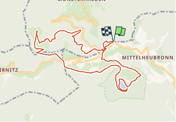
Ruta Senderismo de 11,4 km a descubrir en Baden-Wurtemberg, Landkreis Lörrach, Kleines Wiesental. Esta ruta ha sido propuesta por E.BURCK.
Descripción
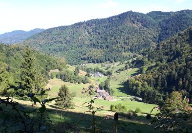
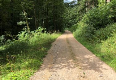
Balade en Allemagne dans le Wiesenthal.
Dénivelé de 310 m et distance totale de 11.3 km :
Wanderparkplatz après le Haldenhof, Nonnenmattweiher, Kreutzweg, Kälbelescheuer, Wanderparkplatz.
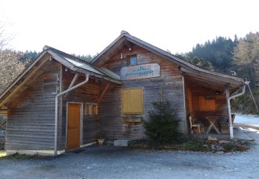
Repas simple dans l' auberge de montagne "Kälbeslescheur"
l'auberge.
ACCÈS :
- au feu rouge avant l'entrée de Neuenbourg, aller tout droit vers Müllheim ( D378), puis Niederweiler, Schweighof, Sirnitz et Haldenhof en direction de Neuenweg et Schönau. (L 131 )
- continuer environ 300 m après l'auberge du "Haldenhof" en direction de Neuenweg.
A partir de la frontière il faut 35 min pour arriver au parking.
PARKING :
- environ 300 m après le Haldenhof, à votre gauche, vous trouverez un parking pour randonneurs, le Wandernparkplatz.
47.80495, 7.79591 ou
N 47°48'17.8", E 7°47'45.3"
RESTAURATION :
Almgaststatte Kalbelescheuer - Tél: 49 7636 / 788887
Accessible facilement par la route:
47.807331, 7.768826 ou
N 47°48'26", E 7°46'08"
Localización
Comentarios
Excursiones cerca
![Excursión A pie Kleines Wiesental - DE-namenlos - Photo](https://media.geolcdn.com/t/375/260/d7076ec6-96b1-475d-8f06-0a8099a48e01.jpeg&format=jpg&maxdim=2)
![A pie A pie](https://static1.geolcdn.com/sitytour/trail-icons/100.png)
A pie
![](/images/other/stat-length.png)
![](https://static1.geolcdn.com/siteimages/upload/files/16400158638029165_repeat_loop_refresh_sync_direction_icon.png)
![Excursión A pie Münstertal/Schwarzwald - Mühlefelsenpfad - Photo](https://media.geolcdn.com/t/375/260/172623ad-d117-48c0-a35e-b7153075611e.jpeg&format=jpg&maxdim=2)
![A pie A pie](https://static1.geolcdn.com/sitytour/trail-icons/100.png)
A pie
![](/images/other/stat-length.png)
![](https://static1.geolcdn.com/siteimages/upload/files/16400158638029165_repeat_loop_refresh_sync_direction_icon.png)
![Excursión Senderismo Münstertal/Schwarzwald - Le Belchen - Photo](https://media.geolcdn.com/t/375/260/bdef32e6-8edd-41a0-b92c-e89506ccb7dc.jpg&format=jpg&maxdim=2)
![Senderismo Senderismo](https://static1.geolcdn.com/sitytour/trail-icons/101.png)
Senderismo
![](/images/other/stat-length.png)
![](https://static1.geolcdn.com/siteimages/upload/files/16400158638029165_repeat_loop_refresh_sync_direction_icon.png)
![Excursión Senderismo Sulzburg - Bad Sulzburg - Photo](https://media.geolcdn.com/t/375/260/feebbc46-5524-4796-852f-af9e498a1922.jpg&format=jpg&maxdim=2)
![Senderismo Senderismo](https://static1.geolcdn.com/sitytour/trail-icons/101.png)
Senderismo
![](/images/other/stat-length.png)
![](https://static1.geolcdn.com/siteimages/upload/files/16400158638029165_repeat_loop_refresh_sync_direction_icon.png)
![Excursión A pie Münstertal/Schwarzwald - Westweg Day 6 Bivouac à bivouac - Photo](https://media.geolcdn.com/t/375/260/ext.jpg?maxdim=2&url=https%3A%2F%2Fstatic1.geolcdn.com%2Fsiteimages%2Fupload%2Ffiles%2F1545311037marcheuse_200dpi.jpg)
![A pie A pie](https://static1.geolcdn.com/sitytour/trail-icons/100.png)
A pie
![](/images/other/stat-length.png)
![](https://static1.geolcdn.com/siteimages/upload/files/16400158638029165_repeat_loop_refresh_sync_direction_icon.png)
![Excursión Senderismo Sulzburg - sulzburg - Photo](https://media.geolcdn.com/t/375/260/ext.jpg?maxdim=2&url=https%3A%2F%2Fstatic1.geolcdn.com%2Fsiteimages%2Fupload%2Ffiles%2F1553511878bg_sport_marche.png)
![Senderismo Senderismo](https://static1.geolcdn.com/sitytour/trail-icons/101.png)
Senderismo
![](/images/other/stat-length.png)
![](https://static1.geolcdn.com/siteimages/upload/files/16400158638029165_repeat_loop_refresh_sync_direction_icon.png)
![Excursión Senderismo Kleines Wiesental - Sirnitz-Nonnenmatt - Photo](https://media.geolcdn.com/t/375/260/786e85d1-de53-4683-a6d3-72a8fb39ab2f.jpg&format=jpg&maxdim=2)
![Senderismo Senderismo](https://static1.geolcdn.com/sitytour/trail-icons/101.png)
Senderismo
![](/images/other/stat-length.png)
![](https://static1.geolcdn.com/siteimages/upload/files/16400158638029165_repeat_loop_refresh_sync_direction_icon.png)
![Excursión Senderismo Münstertal/Schwarzwald - SityTrail - 1144874 - nonnenmatt - Photo](https://media.geolcdn.com/t/375/260/ext.jpg?maxdim=2&url=https%3A%2F%2Fstatic1.geolcdn.com%2Fsiteimages%2Fupload%2Ffiles%2F1553511878bg_sport_marche.png)
![Senderismo Senderismo](https://static1.geolcdn.com/sitytour/trail-icons/101.png)
Senderismo
![](/images/other/stat-length.png)
![](https://static1.geolcdn.com/siteimages/upload/files/16400158638029165_repeat_loop_refresh_sync_direction_icon.png)
![Excursión Senderismo Müllheim - Christian et Shao Fei ji - Photo](https://media.geolcdn.com/t/375/260/ext.jpg?maxdim=2&url=https%3A%2F%2Fstatic1.geolcdn.com%2Fsiteimages%2Fupload%2Ffiles%2F1553511878bg_sport_marche.png)
![Senderismo Senderismo](https://static1.geolcdn.com/sitytour/trail-icons/101.png)
Senderismo
![](/images/other/stat-length.png)
![](https://static1.geolcdn.com/siteimages/upload/files/16400158638029165_repeat_loop_refresh_sync_direction_icon.png)